Αρ. 16306935
Αντικείμενα που πωλήθηκαν
Τελική προσφορά
€ 320
πριν 321 εβδομάδες
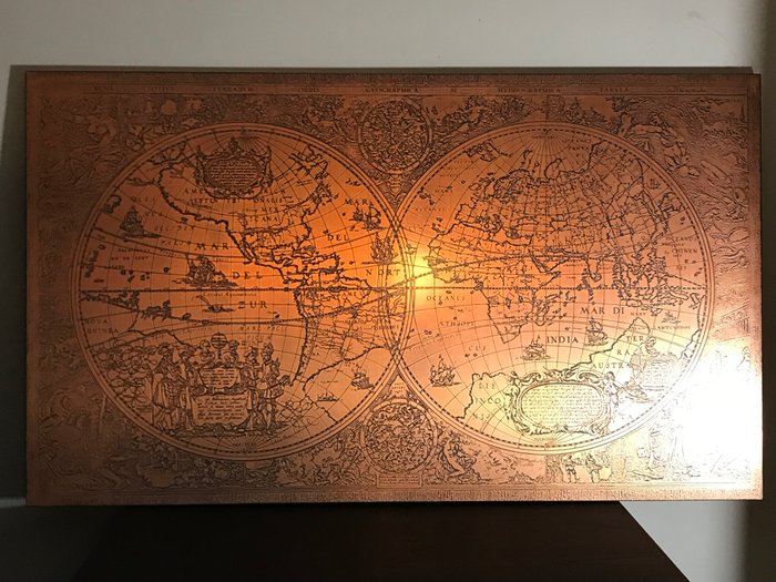
Large map of the world in copper according to Hendrik Hondius

Large map of the world in copper. At the top there is a text in Latin “Nova - Totius - Terrarum - Arbis - Geographica”. AC Hydrographica Tabula.
The original was created by Hendrik Hondius in 1641.
On the left half, we can see North & South America, New Guinea.
Many figures in the foreground with a text about Christopher Columbus.
On the right we can see Europe, Asia, Africa, China, India.
The sea is decorated with ships from the 17th century and some mythological representations.
Many representations on the sides, decorated with water elements, fire, earth and air, and the four seasons.
The plate is glued on a wooden support.
Made in Germany, presumably mid century-1960’s.
In excellent condition and in original packaging.
Dimensions: 120 x 70cm.
Αρ. 16306935
Αντικείμενα που πωλήθηκαν
Large map of the world in copper according to Hendrik Hondius
Large map of the world in copper. At the top there is a text in Latin “Nova - Totius - Terrarum - Arbis - Geographica”. AC Hydrographica Tabula.
The original was created by Hendrik Hondius in 1641.
On the left half, we can see North & South America, New Guinea.
Many figures in the foreground with a text about Christopher Columbus.
On the right we can see Europe, Asia, Africa, China, India.
The sea is decorated with ships from the 17th century and some mythological representations.
Many representations on the sides, decorated with water elements, fire, earth and air, and the four seasons.
The plate is glued on a wooden support.
Made in Germany, presumably mid century-1960’s.
In excellent condition and in original packaging.
Dimensions: 120 x 70cm.
Ορίστε μια ειδοποίηση αναζήτησης
Ορίστε μια ειδοποίηση αναζήτησης για να λαμβάνετε ειδοποιήσεις όταν είναι διαθέσιμα νέα αποτελέσματα.
Αυτό το αντικείμενο παρουσιάστηκε στο
Πώς να πραγματοποιήσετε αγορές στην Catawiki
1. Ανακαλύψτε κάτι ιδιαίτερο
2. Υποβάλετε την κορυφαία προσφορά
3. Πληρώστε με ασφάλεια